
- September 11, 2021
- By Adam Fast
- 2 min read
GeoDjango on Zappa / Lambda
Zappa and AWS Lambda are great prototyping tools (and production tools too) but one that's been missing is GeoDjango.
THE MISSING TOOL
Introduction
In short
- GeoDjango works on AWS Lambda by using the GEOS and GDAL libraries bundled with the RasterIO package, eliminating the need to compile them manually.
- Configure environment variables in zappa_settings.json to point to the RasterIO library paths, then add them to Django settings for immediate use.
- The RasterIO approach adds about 55MB to the function, but extracting only needed files can reduce it to 32MB, staying under the 75MB Lambda limit.
Zappa and AWS Lambda are great prototyping tools (and production tools too) but one tool that’s important to me has been missing from the drawer when I went to build something – GeoDjango. But all I could ever find were a few rough notes that involved compiling the two main libraries, GEOS and GDAL, inside specific Linux distros, bundling them in the app’s folder, and configuring them to be used. Straightforward, but a higher bar than I wanted to jump for free time projects. I would revisit every so often, and finally found this specific comment (https://github.com/Miserlou/lambda-packages/issues/12#issuecomment-478061924) which while not a tutorial was helpful and pretty comprehensive. Maybe there was a hack friendly solution.
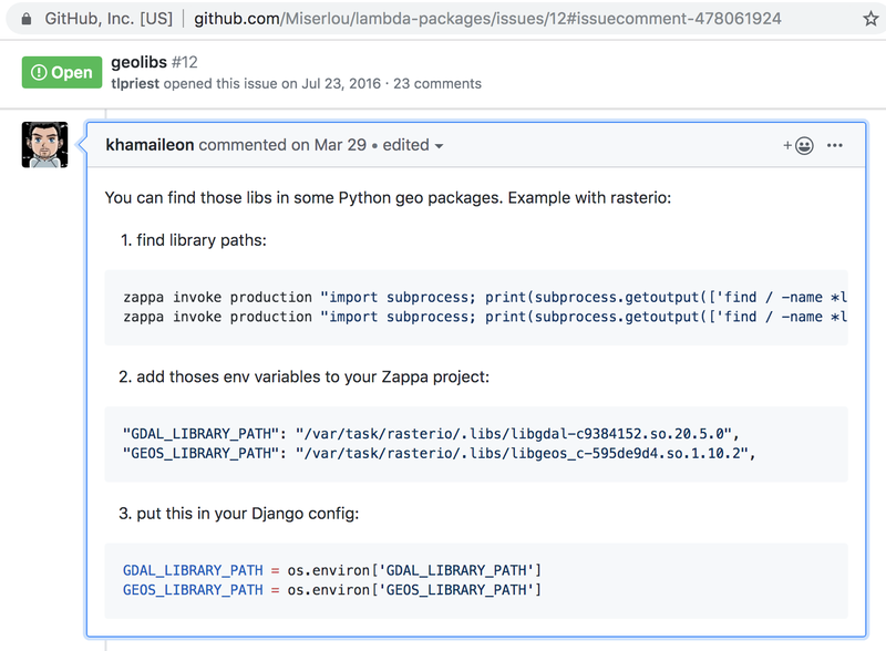
The authors of the RasterIO Python package are already bundling GEOS and GDAL with their library. We can take advantage of that in a clever way I’ll document here, and have deployable geographic apps on Lambda in minutes.
First, add rasterio==1.0.25 to your requirements.txt and install from it.
Django==2.2.5
zappa==0.48.2
zappa-django-utils==0.4.0
rasterio-1.0.25 # installs gdal/geos for us with no hassle
Next, add the following to your environment_variables section of your zappa_settings.json:
Need To Add JSON HERE
"GDAL_LIBRARY_PATH": "/var/task/rasterio/.libs/libgdal-8b68ca59.so.20.5.2","GEOS_LIBRARY_PATH": "/var/task/rasterio/.libs/libgeos_c-595de9d4.so.1.10.2",
Third, configure your Django settings file to grab the newly configured settings:
Add Settings Code HERE
GDAL_LIBRARY_PATH = os.environ.get('GDAL_LIBRARY_PATH')GEOS_LIBRARY_PATH = os.environ.get('GEOS_LIBRARY_PATH’)
At this point, you should be able to "zappa update <env>" and have the libraries available, and be able to work with GeoDjango inside your application. (You will need a spatial database backend to take advantage of most of GeoDjango’s power, that discussion is out of scope for here)
Like many shortcuts, this isn’t the most efficient of approaches – Using RasterIO your project will be about 55MB before you even include your own app code. (Amazon allows up to 75MB for a Lambda function.) If you extract only the files needed from RasterIO’s .libs folder you’ll end up closer to 32MB. (This takes a good bit of trial and error, as the geographic libraries have a number of dependencies and to discover each meant doing a Lambda function release, watching logs to see what errors resulted, adding the next dependency, and re-deploying.)
Note: using Zappa’s slim_handler functionality to get around the code size restriction will change the paths GDAL_LIBRARY_PATH / GEOS_LIBRARY_PATH need to something more like /tmp//rasterio/.libs/libgeos_c-595de9d4.so.1.10.2 If you use a different version of RasterIO, or can’t get the paths above to work the "zappa invoke" command from the GitHub comment should find the file for you.
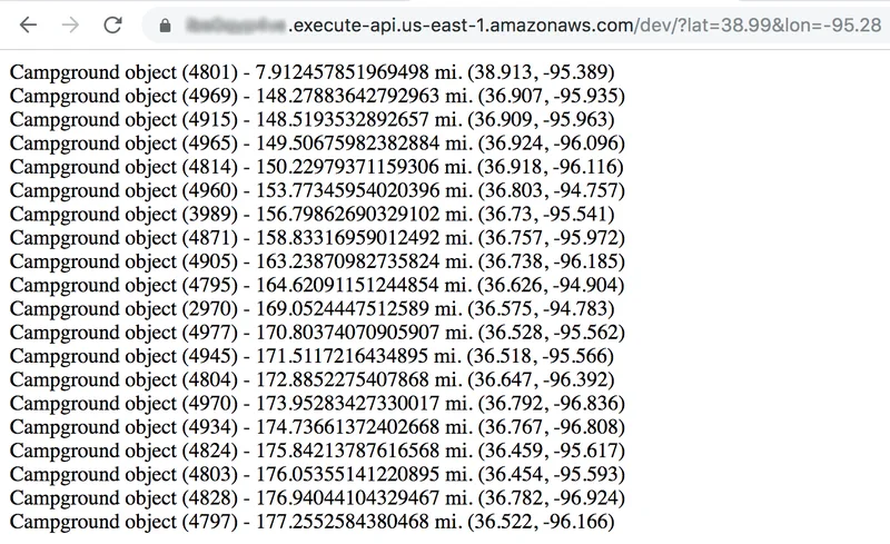
If you need a small app to test things out, you can use https://github.com/adamfast/geodjango-uscampgrounds which has importers / views for a (not recently updated) CSV dataset of campgrounds at http://uscampgrounds.info/takeit.html.
KEEP READING
Related Resources

Case Study
Automating 30,000 Daily Records for a Regional Bank
An AWS Lambda and Python pipeline now runs the transfer daily with no manual work, delivered in just under four months.
Read the regional bank case study
Case Study
Medical Record Extraction for a Healthcare Technology Company
Amazon Bedrock models and AWS Lambda now extract the data into a standard format, with less manual work and more accurate, timely reports.
Read the healthcare technology case study
Case Study
A GenAI Knowledge Base for a Building Materials Manufacturer
Employees ask questions in plain language and get answers almost instantly, from a knowledge base built on Amazon Bedrock and OpenSearch.
Read the building materials case study
